Improving the availability of more high quality imagery is one of the many ways we’re continuing to bring you the most comprehensive and accurate maps of the world. In this month’s update, you’ll find another extensive refresh to our high resolution aerial and satellite imagery (viewable in both Google Maps and Google Earth), as well as new 45 degree imagery in Google Maps spanning 30 new cities.
New high resolution aerial and satellite imagery:
Google Maps and Earth now feature updated aerial imagery for more than 20 locations, and updated satellite imagery for more than 60 regions. Here are a few interesting locations included in our latest release.
Below is imagery of Mecca, Saudi Arabia where each year more than 15 million Muslims visit this important religious site. Here you can see Abraj Al Bait, one of the world largest clock towers, visible even from space!
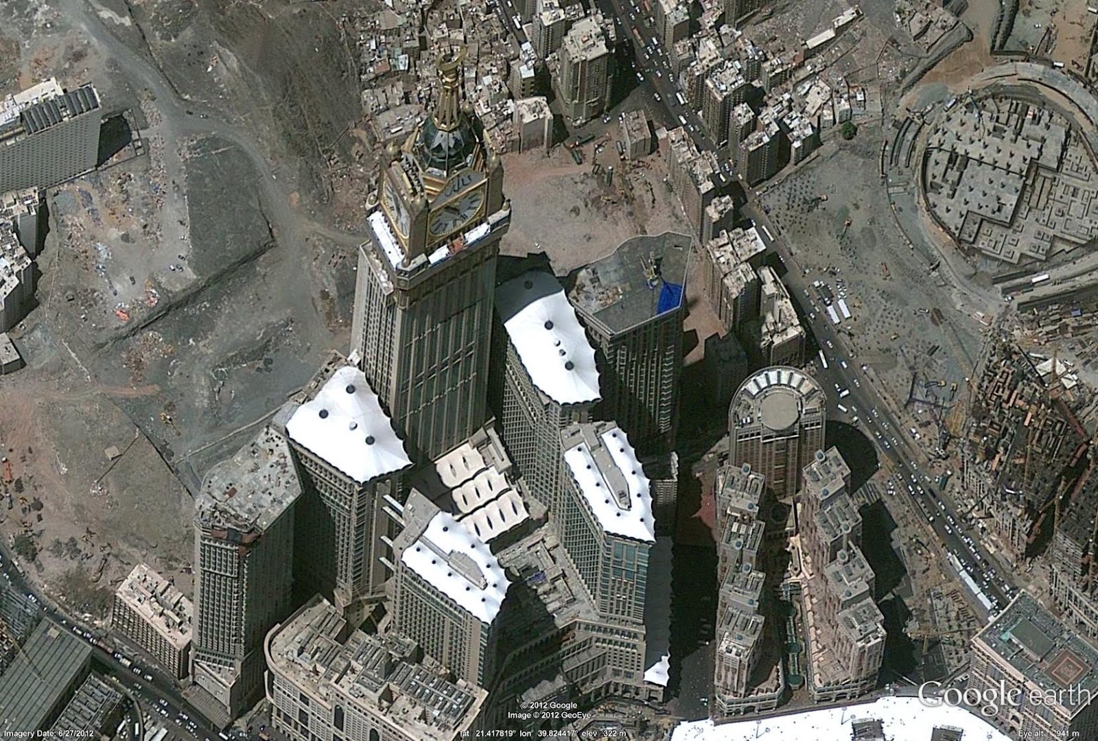
Abraj Al Bait is the world’s largest clock face
On the opposite side of the globe, baseball season in the United States is in full swing and fans can’t get enough. Below is an aerial image of Coca-Cola Park in Pennsylvania, home of the Lehigh Valley IronPigs, a minor league affiliate of the Philadelphia Phillies.
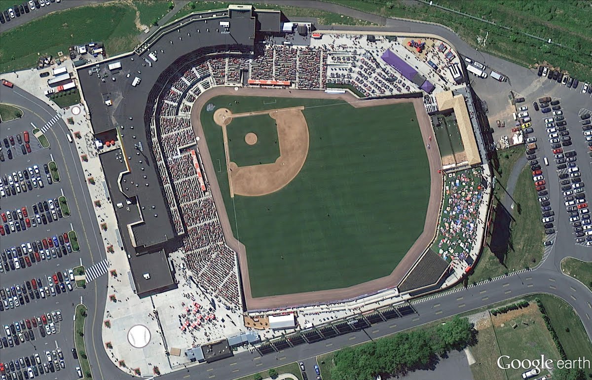
Coca-Cola Park in Allentown, Pennsylvania
New 45° imagery available for 30 cities:
In addition, this month’s Google Maps update includes 45° imagery coverage for 23 U.S. cities and 7 international locations. Below are some highlights from Bordeaux, France and Cincinnati, Ohio.
Bordeaux is a major city in southwestern France, located roughly 45 kilometers from the Atlantic Ocean. It is especially famous for its wine and cuisine, and the image below shows the Gothic style Saint-André Cathedral.
Cincinnati, Ohio, was the first major inland city in the United States known for its large collection of historic architecture . Below is the Over-The-Rhine neighborhood, which exemplifies the historic Italianate Architecture that can be found throughout Cincinnati.
Below is the full list of cities boasting new or updated imagery.
Cities with new high resolution 45° imagery:
United States: Bend, OR; Bloomington, IN; Buffalo, NY; Cincinnati, OH; Columbus, IN; Columbus, OH; Conway, SC; Evansville, IN; Fort Wayne, IN; Gastonia, NC; Hamilton, OH; Indianapolis, IN; Jackson, TN; Joliet, IL; Kokomo, IN; Lincoln, NE; Louisville, KY; Mankato, MN; Muncie, IN; Owensboro, KY; Palm Valley, FL; Rochester, MN; Wilmington, NC.
International: Béziers, France; Bordeaux, France; Lille, France; Marseille, France; St. Etienne, France; Platja d'Aro, Spain; Blanes, Spain.
Areas with new high resolution aerial imagery:
United States: Centralia WA, Tillamook OR, Salem OR, Dos Rios CA, Mount Shasta area CA, Lassen area CA, Joshua Tree area CA, Ely NV, Elko NV, Las Vegas NV, Lander WY, Onawa IA, Ames IA, Perry IA, Bolivar MO, Mountain Grove MO, Rolla MO, Coldwater KS, Spearman TX, Hereford TX, San Antonio TX, Tyler TX, Lafayette LA, Huntsville AL, Waycross GA, Palatka FL, Fort Pierce FL, Allentown PA
Portugal: Torre de Coelheiros
Spain: Baiona, Ourense, Torrelavega, San Sebastian, Pamplona, Nulles, Guadassuar, San Miguel de Salinas, Castellar de la Frontera, Los Palacios y Villafranca, Bailen
France: Bordeaux, Montpellier, Lyon, Dijon, Grenoble
Italy: Livorno, Rome, Catania
Switzerland: Montreux, Neuchatel, Zurich
England: Olympic Park
Germany: Munich, Heidelberg, Flieden, Alsfeld,
Austria: Salzburg
Areas new high resolution satellite updates:
USA, Greenland, Mexico, Colombia, Venezuela, Brazil, Bolivia, Paraguay, Argentina, Antarctica, South Africa, Namibia, Zimbabwe, Mozambique, Zambia, Angola, Democratic Republic of the Congo, Uganda, Kenya, Central African Republic, Cameroon, Ethiopia, Burkina Faso, Guinea, Algeria, Morocco, Western Sahara, Egypt, Saudi Arabia, Syria, Greece, Macedonia, Bulgaria, Romania, Ukraine, Bosnia and Herzegovina, Croatia, Hungary, Poland, Belarus, Lithuania, Estonia, Russia, Khazakhstan, Uzbekistan, Iran, Pakistan, India, Nepal, Bhutan, China, Myanmar, Thailand, Cambodia, North Korea, South Korea, Japan, Philippines, Indonesia, Papua New Guinea, Australia, New Zealand
If you’d like to receive an email notification when imagery for the areas you care about are updated, check out the Follow Your World tool. Enjoy the new sites!
Update (9/7): Satellite and aerial image mentioned is currently available in Google Earth only and will be coming to Google Maps shortly.
Posted by Eric Kolb, Geo Data Strategist


DIGITAL JUICE
No comments:
Post a Comment
Thank's!